New models track vegetation shifts in China’s lakes
GA, UNITED STATES, September 3, 2025 /EINPresswire.com/ -- A new study presents satellite pixel-scale estimation models for aquatic vegetation coverage in lakes, addressing long-standing challenges in ecological monitoring. By integrating Unmanned Aerial Vehicle (UAV), Sentinel-2, and Landsat-8 imagery, the researchers developed a scalable, accurate method to quantify aquatic vegetation coverage and area. These models offer a powerful tool for long-term analysis of lake ecosystem dynamics and carbon sink assessments, with applications ranging from regional water management to global climate models.
Aquatic vegetation plays a vital role in sustaining lake ecosystems, contributing to carbon storage, water purification, and biodiversity. While excessive vegetation can harm biodiversity by reducing light penetration, moderate coverage supports ecological balance. Accurate monitoring of aquatic vegetation area and density is therefore crucial for managing water resources and understanding lake ecosystem health. Traditional satellite-based methods have relied on binary classifications that merely detect presence or absence within a pixel, making it difficult to assess fractional coverage precisely. Based on these challenges, there is a pressing need to develop models that can accurately quantify aquatic vegetation coverage at the pixel level using satellite remote sensing data.
Researchers from the Nanjing Institute of Geography and Limnology, Chinese Academy of Sciences, published a study (DOI: 10.34133/remotesensing.0616) on April 30, 2025, in Journal of Remote Sensing that introduces a stepwise upscaling method for quantifying aquatic vegetation (AV) coverage in lakes. By leveraging Unmanned Aerial Vehicle (UAV), Sentinel-2 Multispectral Instrument (MSI), and Landsat 8 Operational Land Imager (OLI) imagery, they constructed the first satellite pixel-scale models capable of estimating both aquatic vegetation area and fractional coverage. This development addresses critical challenges in monitoring ecological changes across large lake systems, offering new capabilities for long-term vegetation tracking and environmental assessment.
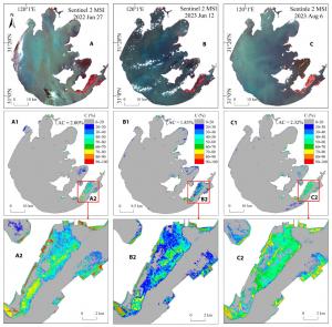
The team developed two novel models—one based on Sentinel-2 and the other on Landsat-8—achieving high accuracy in estimating aquatic vegetation coverage at the satellite pixel scale. The models were developed using a stepwise upscaling method. UAV images captured at 3-cm resolution provided fine-scale vegetation classification via the visible difference vegetation index (VDVI). These data were aligned with Sentinel-2 Multispectral Instrument (MSI) imagery to create a training set, followed by an intermediate Sentinel-based model. Using that model, resampled pixel-level vegetation maps were aligned with Landsat-8 imagery to train a second model. Both models used XGBoost for regression and were evaluated using R², Root Mean Square Error (RMSE), and Mean Absolute Error (MAE) to ensure performance and robustness. The Sentinel-based model, validated with UAV-derived data, achieved an R² of 0.95, while the Landsat-based model, built upon Sentinel data, reached an R² of 0.97.
These models were used to map the vegetation dynamics of 42 large lakes in China’s Yangtze and Huai River basins over three decades. In 2022 alone, the total aquatic vegetation area reached 4,896.4 km², with notable differences in trends: increasing in the Yangtze region and decreasing in the Huai River basin. This pixel-level approach improves precision in ecosystem carbon stock assessment and offers a scalable monitoring framework for global lakes.
“Our work bridges the gap between ground-based small-scale sampling and satellite large-scale observations, offering a scalable, high-accuracy solution for ecosystem monitoring,” said lead researcher Dr. Juhua Luo. “By capturing fractional vegetation coverage at the pixel level, we can support better carbon stock estimates and long-term aquatic ecological studies. This opens new avenues for maintaining aquatic ecosystem stability and health in the face of climate.”
This research lays the groundwork for global-scale, pixel-level mapping of aquatic vegetation using freely available satellite data. The methodology supports integration into carbon budgeting models and lake ecosystem management frameworks. In the future, these models may be extended to estimate aquatic vegetation biomass and lake CO₂ fluxes, helping to track lake carbon sequestration capacity. Continued development could include anti-saturation aquatic vegetation indices and refined models for low and high vegetation density zones. With rising ecological threats, such tools are essential for timely, science-based intervention and restoration planning.
DOI
10.34133/remotesensing.0616
Original Source URL
https://doi.org/10.34133/remotesensing.0616
Funding information
This study was supported by the National Natural Science Foundation of China (42271377, 42271114) and by Science and Technology Planning Project of NIGLAS (NIGLAS2022GS09).
Lucy Wang
BioDesign Research
email us here
Legal Disclaimer:
EIN Presswire provides this news content "as is" without warranty of any kind. We do not accept any responsibility or liability for the accuracy, content, images, videos, licenses, completeness, legality, or reliability of the information contained in this article. If you have any complaints or copyright issues related to this article, kindly contact the author above.

